
After a day of driving past the Patagonian lakes and forests of the Carretera Austral, I am startled by the sight of a small white cross along the edge of the roadway. Wreathed in wilted flowers, it marks the spot where some unfortunate driver met his death along this isolated stretch of road in southern Chile. What startles me, however, is not the eerie reminder of mortality itself, but the fact that this is the first such cross I’ve seen all day.
Most major roadways in South America are studded with such makeshift memorials: white crosses planted along the asphalt; plastic flowers placed near drifts of shattered glass; small concrete shrines to the Virgin Mary along blind curves. By contrast, the forested curves of the Carretera Austral (which is Spanish for “Southern Highway”) are mostly devoid of morbid iconography — testament not to the safety of the road, necessarily, but to the fact that it wasn’t fully completed until four years ago.
A generation ago, the people who lived in this mountainous expanse of Chile’s Aisen province depended largely on the sea to reach the rest of the country. Some “pioneer” villages here date back only to the 1980s, and — in what is perhaps the most novel example of the region’s recent isolation — just three decades ago, locals matter-of-factly converted a crash-landed DC-3 into a house after the Chilean air force determined it was too much of a hassle to go in and recover it.
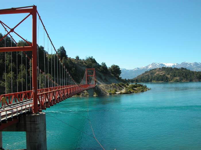
My adventure on Chile’s Carretera Austral is the extension of a journey that began three months ago, when eight companions and I departed Sunnyvale in four Land Rover Discovery II vehicles. Since then, our expedition (known as “Drive Around the World” — a global drive-athon that aims to raise money for Parkinson’s disease research) has crossed 10 countries over a myriad of highways, but no road has quite compared to this far-flung Southern Highway, which has taken us through a stunning landscape of snowy volcanoes, blue-white glaciers, steep fjords, cold rivers and rich swaths of temperate rain forest.
Until yesterday, our transit across South America had largely followed the well-traveled (and well-paved) course of thePan-American Highway. This all changed when we arrived at the southern Chilean city of Puerto Montt, where the Pan-Am doglegs west and comes to a dead-end on the island of Chiloe. Since our expedition had designs on reaching the end of the continent at Tierra del Fuego, we boarded a vehicle ferry at Puerto Montt and steamed across the Gulf of Ancud to catch the Carretera Austral at a town called Chaiten. Here, the wooden clapboard buildings, horseback-riding locals and a penguin-infested bay marked our formal entry into Patagonia — a vaguely defined, yet wildly romanticized territory that marks the beginning of land’s end in South America.
Ever since the region was first discovered and named by Ferdinand Magellan 500 years ago, Patagonia has been associated with the fantastic and the mythical. William Shakespeare‘s “The Tempest” is thought to be influenced byMagellan’s trip report from the region, and Jonathan Swift‘s Brobdingnag giants are said to be modeled on the Tehuelche Indians who once lived here. English explorer James Weddell was convinced that the Fuegan Indians of Patagonia spoke Hebrew, and (as travel author Bruce Chatwin pointed out in his book “In Patagonia”) Herman Melville used the term “Patagonian” as an adjective “for the outlandish, the monstrous, and the totally attractive” in the pages of “Moby-Dick.”Charles Darwin called the region “scarcely passable, and hence unknown,” and rumors of living dinosaurs in the expanses of Patagonia abounded (with the help of credulous newspaper reporting) as recently as 80 years ago.
What distinguishes all these legends, however, is that they apply largely to the Argentine Patagonia — a dry and rocky area that has been compared to Wyoming or Utah. The Chilean Patagonia, on the other hand, with its dense forests and rugged mountains similar to those of Alaska, has historically been too inaccessible to foster even tall tales. Indeed, the closest Aisen province comes to a resident legend is the recycled tale of the “City of the Caesars” – – a forest-shrouded Shangri-La reputed to abound in golden furniture, silver farm implements and beautiful citizens. Originally thought to be located somewhere in the Gobi, the legend was dusted off and relocated to Chile by a pair of Spanish deserters, who wandered through the southern Chilean forests in 1650, and (perhaps in an effort to avoid punishment) claimed to have discovered the legendary city along the way.
Roads, of course, diminish legends just as they diminish isolation. As we make our way south on the Carretera Austral, I notice signs of downright normalcy in Aisen: satellite dishes attached to clapboard houses and log cabins; adventurous Chilean college students hitching rides on the roadside; signs advertising resort lodges and fishing excursions. Indeed, what was recently regarded as Chile’s last settlement frontier has, with the help of this new road, rapidly transformed into a frontier of adventure travel and tourism. The Futaleufu River, near the Argentine border, is gaining a reputation as one of the world’s best whitewater rafting rivers; mountain bikers seek long-haul excursions here in the summer; and Aisen’s salmon and trout-filled rivers are attracting increasing numbers of fly fishermen.
Despite these recent arrivals, however, the old Patagonian way of life is not hard to find. As we drive, we see farmers butchering their sheep by hand near wooden pens; along the road, we pass laborers hauling brush in steer- drawn carts. When we stop to set up camp along the Palena River after a day of driving, we are approached by gray-haired gaucho wearing European-style riding boots and a black felt hat. At first we think he’s angry with us for camping on his land, but after a short exchange in Spanish we realize he’s come to welcome us and ask questions about our Land Rovers. After talking with us for a few minutes, he spots a family standing on the far bank of the river, and gallantly gallops over to ferry them across, one by one, on the back of his horse: first a kind-faced old lady, then a young woman carrying a bundle of flowers, then a teen in a white T-shirt.
Argentine Neighbors
Before the Carretera Austral was constructed, these people had closer overland ties with Argentina than with their countrymen in the Chilean north. Settlers began arriving here by sea about 100 years ago under a government program that handed out land and encouraged homesteading — but the pioneers ultimately found that overland trade with Argentina was more practical than depending on Chilean seaports. This cross-border trade proved a boon to settlers in Argentine Patagonia as well, including a transplanted American named Butch Cassidy, who marveled in a 1902 letter that “it is over 1,600 miles to Buenos Aires and over 400 miles to the nearest seaport, but only 150 miles to the Pacific coast [in Chile].” Had Butch and his partner Sundance not been gunned down in Bolivia seven years later, he could have taken advantage of Chilean government incentives and moved to Aisen himself.
It was because of this cozy trans-Patagonian proximity that the Chilean government ultimately decided to make Aisen province more accessible from the north of the country. Fearing that the region was vulnerable to Argentine designs on claiming a Pacific port of its own, Chilean dictator Augusto Pinochet commenced the Carretera Austral project in 1976. The bulk of the $300 million project was completed in 1988; in 2000, road crews completed a final stretch south to Villa O’Higgins, where permanent ice fields make further roads impossible. All told, the Carrertera Austral stretches over 700 miles down the far end of the South American continent.
Regardless of how history will judge Pinochet, the residents of Aisen seem to appreciate him. On our second day of driving south through misty valleys and old logging camps, we pass through a town called La Junta, which features a commemorative monument to the infamous general. When I ask the proprietor of the local snack-shop what she thinks of this, she shrugs. “Pinochet did good things for this part of Chile,” she says. “Without the Carretera Austral, we wouldn’t exist.”
Capital Improvements
Of all the civic beneficiaries of Pinochet’s road, the biggest is undoubtedly Coyhaique, Aisen’s capital. Founded on the site of a German- immigrant estancia in the 1920s, Coyhaique’s natural setting initially suffered from arcane government policies that encouraged indiscriminate land clearing in the 1930s and 1940s (3 million hectares of virgin forest, it is thought, were burned up in a single decade). The town has thrived with the completion of the Carretera Austral, however, and is now home to 42,000 people and numerous warm-weather tourists. One secret of Coyhaique’s boom is revealed to me just outside the city limits, where I pick up a young Canadian hitcher named Jim Allen, who works as a fly-fishing guide in the area. “It’s a great job,” he tells me as we cruise into town. “When the fishing season ends in British Columbia, I come to Chile. Aisen has a reputation as the hottest place in fly-fishing right now, and it’s a huge winter destination for North Americans. I stay busy all season.”
In addition to fishing, Coyhaique is a staging area for the temperate rain forests of Queulat National Park, and it boasts nearby ski runs in the winter. Unfortunately, the urgencies of my transit to Tierra del Fuego don’t allow me to linger in Coyhaique, as my expedition team continues south into a drier stretch of Aisen, which — with its windswept grasslands and basalt massifs — looks a lot like Montana. Because there is no border crossing into Argentina at Villa O’Higgins, my companions and I cut short our Carretera Austral journey at Lago General Carrera (South America’s second-biggest lake) and head east. We camp for the night on the banks of the Maiten River, which flows into the huge lake through a series of rapids.
Our steady road progress hasn’t allowed me much time to enjoy the Patagonian wilderness, so I don a wetsuit, commandeer an empty jerry can, and (accompanied by our expedition videographer) ride the river out to the mouth of the lake. Inspired, I hike back upriver and do it again. At night, my companions and I build a campfire and stare up at the stars glittering over the snowcapped mountains. We’ve picked our campsite more or less at random, but it’s the kind of setting that makes one realize how the world is full of such anonymously beautiful places. Places where you’d like to have more time to linger.
The following day is our last in Aisen. Driving along the shore of Lago General Carrera, we make our way east to the border town of Chile Chico. As I step out of my Land Rover to search for lunch spot, the ground swirls with puffs of dust — the legacy of the 1991 eruption of the nearby Hudson volcano, which launched a cubic mile of ash across this corner of Patagonia. Ash aside, I notice that the land has become noticeably more desertlike, hinting at our transition into the drier Patagonian steppes of Argentina.
More than 200 years ago, when explorers were still keeping an eye out for the “City of the Caesars,” one over imaginative Chilean expedition party concluded that the legendary city was located “just south of 45 degrees latitude, on a lake near a volcano.” By my reckoning, the nearest place fitting that description is Chile Chico. But while the City of the Caesars was said to be a utopia of perfect health, garden vegetables as big as trees and bounteous treasure, this town appears to be just another dusty, nondescript border post.
The treasure, of course, comes in getting here. Brandishing my passport, I cross the border into the well-worn roads of Argentina.